Johnson County government website 
Population (2006): 516,731
Area: 476 square miles
Population density: 1,085 per sq mi
County History
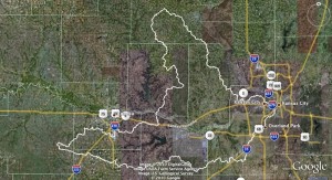
Detailed information is available from the River Inventory for
Johnson County
View Kansas River Inventory-Johnson County in a larger map. Click here for help with maps.
De Soto – River mile 31
De Soto government website
Population size: 5,369
Square miles: 11.3
Population density: 475 people per sq mi
Watershed: Lower Kansas River HUC number 10270104
Lower Kansas River HUC 10270104
Boat access points: De Soto Riverfest Park Access at river mile 31
Bridges over Kaw: Wyandote St. at river mile 30.7
River dredges/Off river pit mines: none – the river above and below De Soto is in a “No Dredge” Zone because of river bed degradation.
Wastewater treatment: De Soto WWTP (Pop. served: 4,541)
Click on map markers for data from EPA MyEnvironment
Fairway
Fairway government website
Population size: 3,832
Square miles: 1.14
Population density: 3,361 people per sq mi
Watershed: Lower Missouri River/Crooked HUC number 10300101
Boat access points: Kaw point- Lewis and Clark Historic Park
Lake Quivira – River Mile 14
Lower Kansas River HUC 10270104
Population size: 935
Square miles: 1.3
Population density: 719 people per sq mi
Watershed: Lower Kansas River HUC number 10270104
Boat access points: Edwardsville
Portage path is completed on the north side of the WaterOne Coffer Dam and this site is being considered for a future access park.
Lenexa
Lenexa government website
Population size: 45,681
Square miles: 34.3
Population density: 1,332 people per sq mi
Watershed: Lower Kansas River HUC number 10270104
Boat access points: Cedar Creek at river mile 26.2
Edwardsville at river mile 17
Merriam
Merriam government website
Population size: 10,790
Square miles: 4.32
Population density: 2,498 people per sq mi
Watershed: Lower Kansas River HUC number 10270104
Boat access points: Kaw Point at river mile 0
Mission
Mission government website
Population size: 9,743
Square miles: 2.53
Population density: 3,851 people per sq mi
Watershed: Lower Kansas River HUC number 10270104 & Lower Missouri River/ Crooked HUC number 10300101
Boat access points: Kaw Point at river mile 0
Mission Hills
Population size: 3537
Square miles: 2.02
Population density: 1,751 people per sq mi
Watershed: Lower Missouri River/Crooked HUC number 10300101
Boat access points: Kaw Point at river mile 0
Mission Woods
Population size: 159
Square miles: 0.11
Population density: equivalent to 1,445 people per sq mi
Watershed: Lower Missouri River/Crooked HUC number 10300101
Boat access points: Kaw Point at river mile 0
Olathe – River mile 26
Olathe government website
Population size: 118,034
Square miles: 54.2
Population density: 2,178 people per sq mi
Watershed: Lower Kansas River HUC number 10270104 & Lower Missouri River/Crooked HUC number 10300101
Boat access points: Cedar Creek Access at river mile 26.2
In-river dredge permits: none
Off river pit mines: Masters Dredging Co., 8220 Gardner Rd.
Water Discharge Permits
Click on map markers for data from EPA MyEnvironment
Overland Park
Overland Park government website
Population size: 169,403
Square miles: 56.7
Population density: 2,988 people per sq mi
Watershed: Lower Kansas River HUC number 10270104 & Lower Missouri River/Crooked HUC number 10300101
Boat access points: Cedar Creek Access at river mile 26.2
Water Discharge Permits
Click on map markers for data from EPA MyEnvironment
Prairie Village
Prairie Village government website
Population size: 21,422
Square miles: 6.22
Population density: 3,444 people per sq mi
Watershed: Lower Missouri River/Crooked HUC number 10300101
Boat access points: Kaw Point
Roeland Park
Roeland Park government website
Population size: 6,951
Square miles: 1.62
Population density: 4,291 people per sq mi
Watershed: Lower Kansas River HUC number 10270104 & Lower Missouri River/Crooked HUC number 10300101
Boat access points: Kaw point
Shawnee – River miles 27-21
Shawnee government website
Population size: 59,958
Square miles: 41.7
Population density: 1,438 people per sq mi
Watershed: Lower Kansas River HUC number 10270104
Boat access points: Access planned at future Shawnee River Front Park at river mile 22.5
Bridges over Kaw:
KS Highway 7 at river mile19.8
I-435 at river mile 15
In-river dredges permits: none
Off river pit mines: HSB Acquisition Co, LLC (formerly Holliday Sand and Gravel) at 21900 West 43rd Street (partially in Bonner Springs) and future pit mine in the general vicinity of the 4700 block of FrisbieRoad.
Westwood
Population size: 1,478
Square miles: 0.40
Population density: equivalent to 3,695 people per sq mi
Watershed: Lower Missouri River/Crooked HUC number 10300101
Boat access points: Kaw Point at river mile 0
Westwood Hills
Population size: 363
Square miles: 0.07
Population density: equivalent to 5,186 people per sq mi
Watershed: Lower Missouri River/Crooked HUC number 10300101
Boat access points: Kaw Point at river mile 0.